Dickinson Co. Supervisors Review East Okoboji Beach Map Discrepancy
Dickinson Co. Supervisors Review East Okoboji Beach Map Discrepancy
May 24, 2022Steve Schwaller
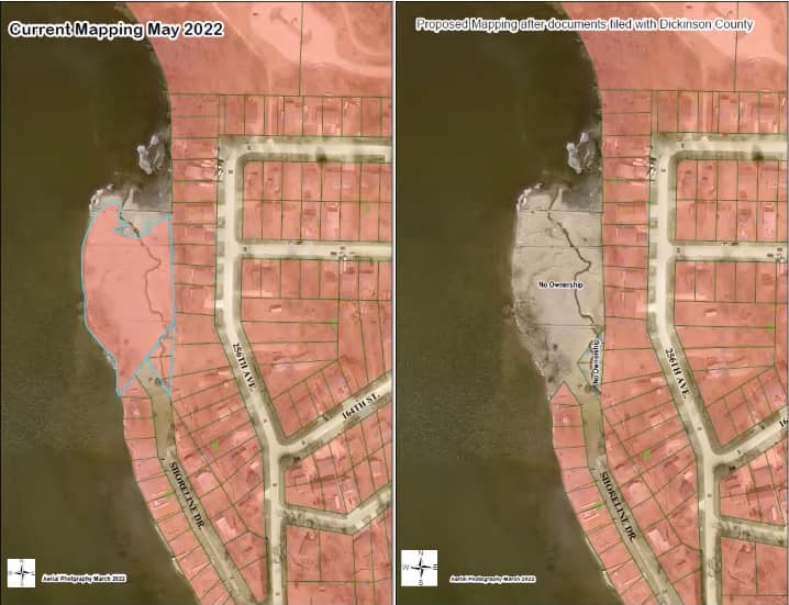
(Spirit Lake)– Dickinson county supervisors today (Tues.) reviewed a map revision for a portion of the East Okoboji Beach Subdivision. It pertains to where the shoreline boundary is located on plat maps. The matter was brought to their attention by Paul Assman (ozz-man), a property owner in that area who discovered a discrepancy with some lots that were actually discovered to have been platted into the lake following a shoreline survey in 1961…
“What should have happened in 1961 when they did the land transaction, they should have filed a corrected subdivision plat, and that didn’t get done. Had that got done there would be no ambiguity. This would have all been cleared up a long time ago, but that never happened. I think they did what they thought was probably the right thing, the appropriate thing. They did the land exchanges, but they never kind of closed the circle, if you will, and filed that corrected subdivision plat, so.”
Assman says it’s basically a technicality…
“In the simplest form, all of the legal documents, all of the title documents, have existed since then. It’s just that no one has kind of taken and put all of the pieces of the puzzle together and said this is what the map should like.”
No action was taken nor was it required of the supervisors. The revised map will now be recorded in documents with the Recorder’s Office.