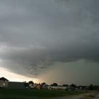
(Undated)– A very large and dynamic storm is going to bring a wide variety of adverse weather to the region over the next couple of days.
The National Weather Service has issued a winter storm watch for a large part of southwest Minnesota, with the exception of the far southern tier of counties, from Friday morning through late Friday night. Some parts of the region, meanwhile, could experience their first thunderstorms of the season tonight and Friday, with even the possibility of some isolated severe storms with large hail being the primary threat. Whatever precipitation is left over will turn to snow throughout the entire region by later in the day Friday into Friday night as temperatures drop.
Up to 8 inches of snow could fall in those areas of southwest Minnesota under the winter storm watch Friday and Friday night, with blizzard conditions possible. Snowfall amounts locally in the Iowa Great Lakes will be much less, along the line of 1 to 2 inches.
Another storm will likely impact the region Tuesday and Wednesday of next week with more rain and snow.